


ISS Transit Prediction
Descrizione di ISS Transit Prediction
Questa applicazione genera previsioni di transito della Stazione Spaziale Internazionale (ISS) per il Sole, la Luna e i Pianeti.
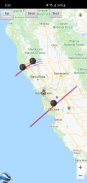
L'utente specifica una posizione, che include latitudine, longitudine e altitudine. L'applicazione scarica le informazioni orbitali più recenti. L'applicazione genera una mappa di previsione del transito che contiene i percorsi di previsione per ciascun transito all'interno di un raggio di avviso specificato.
Solo versione Pro: specifica e salva più posizioni, salva più mappe di previsione per una visualizzazione successiva, aggiungi trasporto pubblico al calendario, visualizza mappe con Google Earth, due elementi di linea specificati dall'utente. Nessuna pubblicità.
Solo versione Pro: disponibile per l'acquisto in-app: sblocca satelliti aggiuntivi: calcola i transiti per qualsiasi satellite, inclusa la stazione spaziale Tiangong e il telescopio spaziale Hubble.
INTERFACCIA UTENTE
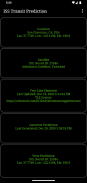
La schermata principale prevede 5 pulsanti:
•Posizione: premere questo pulsante per aggiungere o selezionare la posizione di generazione della previsione
•Satellite: premi questo pulsante per cambiare il satellite di transito (solo versione Pro, è richiesto l'acquisto in-app)
•Due elementi di linea (TLE): premere questo pulsante per scaricare gli elementi orbitali
•Genera previsione: premere questo pulsante per avviare la generazione della previsione
•Visualizza previsione: premere questo pulsante per visualizzare la mappa di previsione o il file di testo
Il menu delle opzioni fornisce quanto segue:
•Posizioni: premi per aggiungere, selezionare, modificare o eliminare le posizioni salvate (solo versione Pro)
•Previsioni: premi per visualizzare, condividere o eliminare le mappe di previsione salvate (solo versione Pro)
•Impostazioni - Premere per impostare le preferenze dell'utente
•File DEM: premere per elencare o eliminare i dati DEM (Digital Elevation Model) scaricati
•Aiuto: premere per visualizzare questa pagina della guida
•Informazioni: premere per visualizzare la versione dell'applicazione, i crediti e i collegamenti
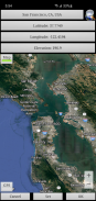
POSIZIONI
Aggiungi una posizione di osservazione con nome facendo clic sul pulsante "Posizione" accessibile dalla schermata principale.
Le coordinate della posizione possono essere inserite in uno qualsiasi di questi metodi:
•Manualmente: inserisci latitudine, longitudine e altitudine nelle caselle di testo. I valori positivi rappresentano il Nord e l'Est, i valori negativi il Sud e l'Ovest. L'altitudine può essere inserita in metri o piedi sopra il livello del mare a seconda dell'impostazione corrente delle unità di previsione.
•Cerca: premere il pulsante di ricerca per cercare una posizione.
•Inserimento mappa: utilizza la mappa per eseguire lo zoom e la panoramica su una posizione. Premendo il pulsante Imposta si imposta il nome della posizione, le coordinate e l'elevazione nelle caselle di testo. L'elevazione delle coordinate correnti viene recuperata utilizzando l'impostazione dell'origine dati elevazione specificata. Passa dalla modalità mappa a quella satellitare attivando il pulsante Mappa/Sat.
•GPS - Premendo il pulsante GPS, l'applicazione utilizza il GPS per ottenere le coordinate della posizione e l'elevazione.
Utilizza la pagina delle posizioni accessibile dal menu delle opzioni per modificare ed eliminare le posizioni salvate. (Solo versione Pro)
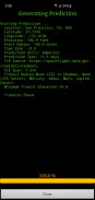
GENERARE PREVISIONI
Una volta inserita la posizione e scaricato il TLE, premere il pulsante "Genera previsione" per avviare la generazione della previsione. La barra di avanzamento fornisce un'indicazione di quanto tempo sarà necessario per completare il processo. A seconda della velocità del processore, potrebbero essere necessari alcuni minuti per generare le previsioni. Premendo il pulsante Annulla si annullerà la previsione.
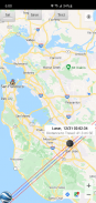
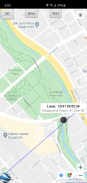
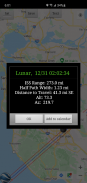
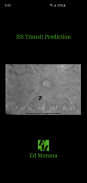
VISUALIZZAZIONE PREVISIONI
Una volta completata la generazione della previsione, è possibile visualizzare la mappa di previsione o il file di testo. Premendo il pulsante Visualizza previsione viene visualizzata la mappa di previsione generata in precedenza. Il pulsante di testo nella visualizzazione mappa visualizza il testo della previsione. Il pulsante Mappa/Sat commuta tra la modalità Mappa e la modalità Satellite.
Nella visualizzazione mappa, premi il pulsante Google Earth per visualizzare la mappa in Google Earth (solo versione Pro). Premere il pulsante Salva per salvare la previsione per una visualizzazione successiva (solo versione Pro).
Nella finestra delle informazioni sul trasporto pubblico, premi il pulsante Aggiungi al calendario per creare un evento nel calendario (solo versione Pro).
Utilizza la pagina delle previsioni accessibile dal menu delle opzioni per visualizzare, condividere ed eliminare le mappe di previsione salvate in precedenza (solo versione Pro).
PERMESSI
Posizione: richiesta solo se viene selezionata l'opzione GPS durante l'immissione della posizione
ISS Transit Prediction - Versione 3.1.1
(28-06-2024)ISS Transit Prediction - Informazioni APK
Versione APK: 3.1.1Pacchetto: com.ed_morana.iss_transit_prediction_freeUltima versione di ISS Transit Prediction
Altre versioni


 4.14
4.14


 4.67
4.67
App nella stessa categoria

Potrebbe piacerti anche...


